
Crest Hill Neighbors: Which Sources Answer Which Questions
The official record is strongest when the question is narrow. Will County GIS can define which parcels touch. The assessor provides a current parcel index. Crest Hill maps and records add ward, subdivision, planning, and service context. HOA registrations can identify an association and its declaration trail, while voter tools are designed for status checks rather than a block roster.
| Official layer | Block-level evidence | Practical access |
|---|---|---|
| Will County GIS Data Viewer | Parcel shapes, adjacent parcels, roads, and selected county layers | Free interactive map; save layer names and the date viewed |
| Supervisor of Assessments portal | PIN, owner index, address, class, sale and subdivision context | Six free search modes; township assessor handles accuracy questions |
| Crest Hill street and ward map | Named streets, wards, subdivisions, and city reference geography | City PDF; confirm current conditions with GIS or the Clerk |
| HOA registration and meeting files | Association, subdivision, declaration number, boundary discussion, and public officer fields | No public register verified; request an existing file from the City Clerk |
| Voter status tools | A person's own status and precinct or polling information after required inputs | Purpose-limited forms; not a public nearby-resident list |
An owner entry can differ from the occupant and from the mailing address. Record the source's own field label, such as parcel address, mailing address, municipality, or subdivision. That small habit prevents the most common neighbor-search error: merging distinct administrative facts into one household claim.
Will County GIS Frames Crest Hill Neighbors as Parcels
The Will County GIS Data Viewer guide describes a map with more than seventy layers and tools for parcel selection, measurement, and spatial analysis.
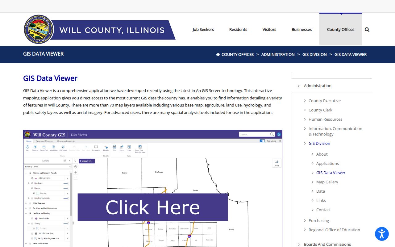
Use the map to establish geometry, not identity. Locate the subject parcel, click the shapes that directly touch it, and record their PINs. A nearby point across a road or behind a lot may feel close but is not parcel-adjacent. If the interface or layers fail, the fallback is a map review with GIS or assessor staff using the subject PIN and neighboring parcel IDs.
Build a Crest Hill Neighbors Map from One Address
The adjacent-parcel method keeps the scope clear. Begin with one verified parcel, then walk outward one lot at a time. Match by PIN across GIS and assessor pages before adding an owner-index label.
- Search the full address in the Will County assessor portal and copy its PIN and municipality.
- Locate the same PIN in GIS, select the parcel, and note the active map layers and date.
- Select each touching parcel and log only its PIN and geometric relation at first.
- Open each PIN in the assessor index and keep owner, mailing, and situs fields separate.
- Use the Recorder only when a specific deed or declaration is needed, then cite its document number.
This process describes recorded parcels around an address, not a social network. For a full road rather than the immediate ring of lots, the Crest Hill street directory explains the by-address record chain.
Crest Hill Neighbors and the HOA Record Layer
Crest Hill's HOA registration rule creates a local source that parcel sites do not. Registration calls for the association's declarations or covenants, a Recorder document number or state certification, officer contact fields, and a business-entity name and address. Updates are due annually, with changes reported within the period stated by the ordinance. The public register itself was not found online.
| Record target | Why it helps | Best request wording |
|---|---|---|
| Registered association name | Connects the block or subdivision to the correct entity | Ask for the existing registration by subdivision and registration year |
| Declaration document number | Routes the search to the recorded instrument | Request the number, then retrieve that instrument from the Recorder |
| Boundary attachment | May explain association or drainage discussion | Name the meeting date or packet and ask for the attached map |
| Officer-contact fields | Identifies a public association role | Request the existing fields with protected details redacted where required |
This is a better route than asking the City to compile a list of private block residents. It seeks an existing administrative file tied to a subdivision and recorded declaration.
A Crest Hill Meeting Attachment Is a Boundary Clue
An official Crest Hill work-session record includes an attachment titled “HOA Boundries.pdf” in storm-drainage discussion.
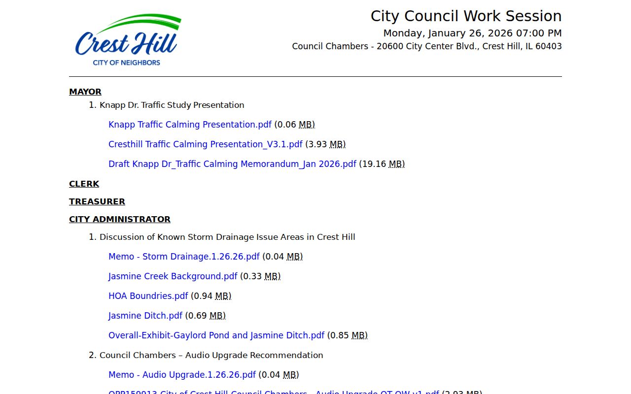
Meeting attachments can be timely and useful, but their purpose matters. Compare the packet map with the recorded declaration, current GIS, and the City Clerk's registration file. Do not merge a discussion map with a tax lot, ward, or official association boundary unless the documents explicitly connect them.
Crest Hill Neighbors Sit in Overlapping Districts
A Crest Hill block can carry a city label while its parcel record sits in a Plainfield or Lockport township context. The city's Fire page also identifies Lockport Township and Plainfield Township fire-protection service areas. ZIP, township, municipality, subdivision, ward, and fire district answer different questions, so the PIN and current map are safer anchors than a postal name alone.
Parcel relation
GIS and tax-map lines define adjoining lots for a dated map view.
Administrative relation
Township, ward, fire district, subdivision, and HOA layers may overlap without sharing boundaries.
Social relation
No official layer proves that two owners, occupants, or households know one another.
Carillon Lakes, Remington Lakes, Arbor Glen, Fields of Long Meadow, Renaissance Crossing, and other names appear on city or operational sources. Preserve the source beside each label instead of presenting all names as one official neighborhood system.
A Crest Hill Block Can Have Several Kinds of Nearness
Parcel adjacency is only one measurable relationship. Crest Hill planning states that owners within 300 feet of a public-hearing project receive mailed notice, while the legal notice appears in a local newspaper. That radius serves a planning process and may reach lots that do not share a boundary with the project. The recipient list should not be republished as a resident roll. Ask instead for the public notice, project file, map, agenda packet, written comments, or plan-commission record by street, PIN, and hearing date.
An HOA boundary serves another purpose. A ward maps representation. A tax sheet organizes assessment work. A fire district describes emergency service, and a hydrant zone organizes flushing. Even when all five cross the same block, their lines need not match. Write the source and revision date beside each one. If the city map and live GIS disagree, retain both observations and ask the Clerk, GIS office, or relevant custodian which current record controls the question.
This distinction also makes a block inquiry more useful. Someone researching drainage may need the work-session packet and association declaration. Someone checking a shared lot edge needs parcel geometry and perhaps a recorded plat. Someone following a public hearing needs the project notice and zoning file. The geographic question determines the record, while the record's stated purpose limits what can fairly be concluded about people nearby.
Seven Crest Hill Zones Offer Hyper-Local Map Vocabulary
The Crest Hill hydrant-flushing page groups streets and areas into seven operational zones.
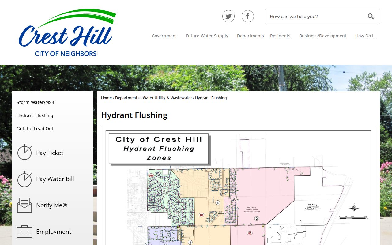
These zones are helpful when someone recalls an area but not a complete address. They reference places such as Caton Farm Road from Weber to Broadway, east and west Borio, Fields of Longmeadow, Remington Lakes, Carillon Lakes, Cambridge Crest, Oakland, Burry Circle, and Willow Falls. Yet a hydrant zone is not a ward, tax code, HOA, ZIP, or cluster of nearby households. Use it only to generate street terms for the parcel map.
Official Crest Hill Neighbor Records Versus Commercial Tools
Official systems separate parcel geometry, assessment, legal instruments, voter status, and municipal files. That separation can feel slower, but it preserves the source and date of each fact. Commercial neighbor-search products may blend public copies, marketing data, self-reported details, and inferred associations into one display. Their update cycles and accuracy vary, and the merged output can conceal which custodian supplied a claim.
| Choice | Strength | Limit |
|---|---|---|
| Official parcel and GIS sources | Clear PIN, map layer, custodian, and date | Owner or parcel does not equal occupant |
| Official city and HOA files | Existing civic record, declaration, or meeting context | Redactions and no verified public HOA register |
| Commercial category | May collect clues in one place | Source mixing, stale links, inferred ties, and uncertain refresh timing |
Privacy Boundaries for Crest Hill Neighbors
The voter-status forms require identity and address inputs and are not a public residents-by-block directory. Illinois voter-file rules restrict disclosure and use, and the Attorney General's Address Confidentiality Program protects eligible survivors through substitute-address treatment under 750 ILCS 61/30. A missing voter or address result can reflect lawful protection, input mismatch, a different custodian, or portal coverage. It is not proof that no one lives there.
Assessor ownership is also not household membership. Utility, delivery, emergency-card, and other sensitive records are not substitutes for public neighbor rolls. Keep inquiry focused on parcel geography, civic records, and a legitimate personal reason.
Lawful use. Explore people and records around a Crest Hill block for civic curiosity, reconnecting, or personal safety awareness. Never use public clues to watch, harass, intimidate, or harm anyone.