
Crest Hill ZIP Code Crosswalk
Official USPS material ties five postal zones to Crest Hill labeling, but the rows are not claims that each zone lies wholly within city limits. The core last line is CREST HILL IL 60403. Other rows document neighboring or historical relationships. Use the table as a dated postal crosswalk, then verify a specific street with USPS, the assessor, GIS, and the city map.
| ZIP | Areas Covered | Postal Note | Local Check |
|---|---|---|---|
| 60403 | Core Crest Hill delivery area | Official Crest Hill last line | Edges may not match city limits |
| 60404 | Area formed from part of 60431 in 2006 | Original change note used Shorewood routing | Not a separate Crest Hill boundary |
| 60431 | Former and adjacent delivery relationship | Source area for the 60404 split | Old directories may retain it |
| 60434 | Joliet/Crest Hill labeling relationship | Institutional mail may use this zone | Check physical address and parcel |
| 60435 | Joliet-area zone with partial Crest Hill labeling history | Some former deliveries changed to 60403 | Postal city is not proof of municipality |
The 2006 bulletin, 2022 labeling table, and 2025 FAST scheme are snapshots from different dates. Preserve the publication or effective date beside any conclusion. Postal standards change, while a deed or historical directory stays tied to its original date.
Crest Hill ZIP Lookup Modes
The USPS ZIP Lookup offers three useful modes. By Address verifies a delivery label from a full street address. By City and State discovers the ZIP codes associated with a named postal city. Cities by ZIP returns recognized or recommended city names for one five-digit code. These are postal answers, not resident or municipal records.
| Mode | Main fields | Useful result |
|---|---|---|
| By Address | Street, city, state, ZIP; company and unit optional | Current delivery formatting |
| By City and State | City and state | Postal zones tied to the city name |
| Cities by ZIP | Five-digit ZIP | Recognized city labels |
A live Crest Hill city-and-state result was not captured during unattended research because the endpoint denied access. Use the official interface for a current search rather than inferring a result from an old bulletin. If a legal, vital, or records form will be mailed, also confirm the custodian's current contact page.
Crest Hill ZIP Label Records
The USPS FAST L007 file effective August 1, 2025 lists the Crest Hill scheme across 60403, 60404, 60431, 60434, and 60435. It is a strong source for the postal relationship because it comes from USPS operations. It is still a labeling file, not a city-boundary survey.
The captured L007 labeling record appears below.
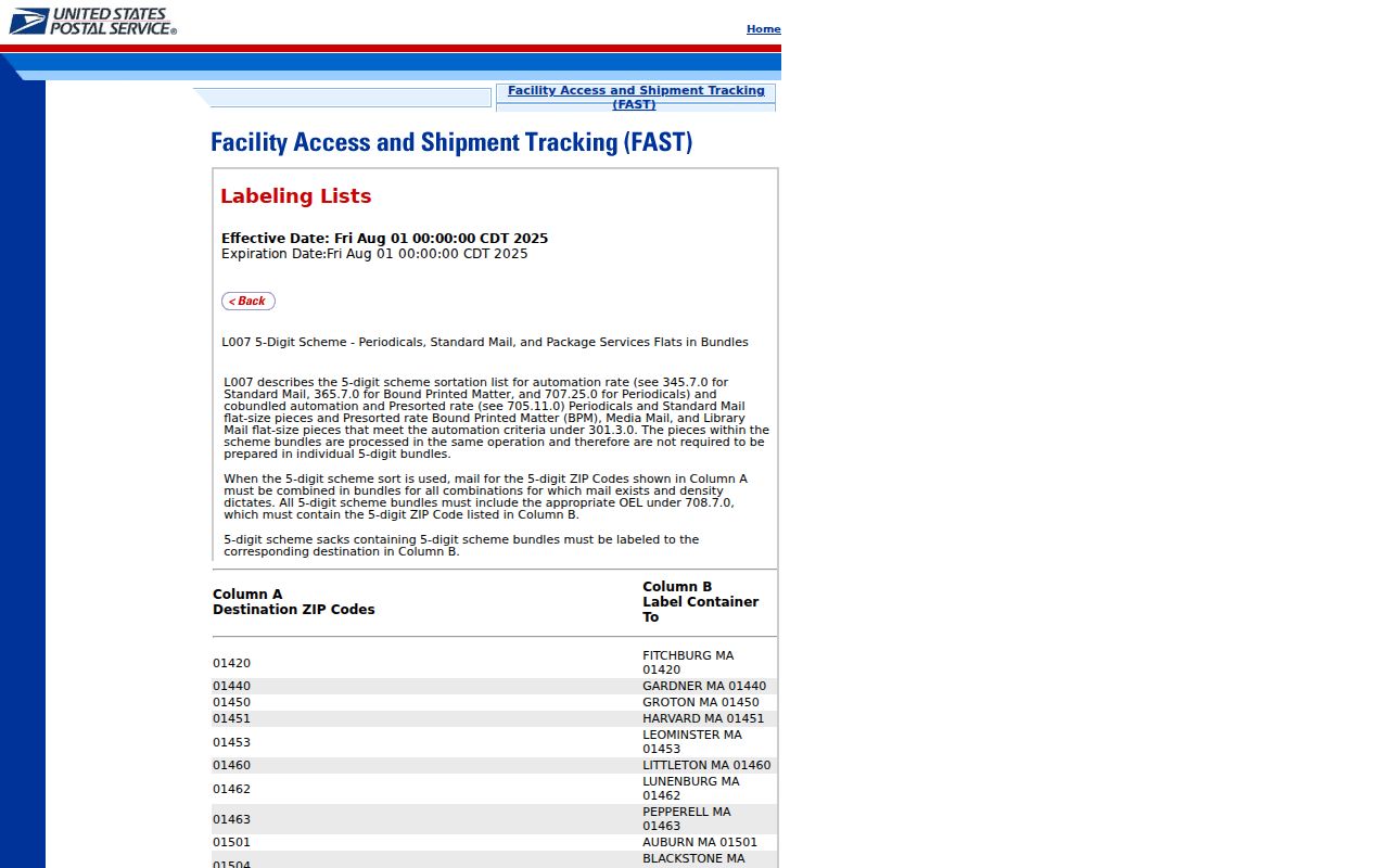
The view supports the crosswalk, but a current full-address result should control mailing decisions. Save the file's effective date whenever it is cited.
Find Crest Hill Residents by ZIP
A ZIP can narrow a search, but it should not be the sole identity anchor. Begin with the official delivery label, move to the parcel index, and then use the record system that fits the actual question. The assessor form does not expose a ZIP field in the inspected version, so search street number, street name, and city instead. Recorder DirectSearch does have an advanced Address tab with a Zipcode field.
- Enter the full address in USPS lookup. Save both the recommended last line and five-digit code.
- Search the Will County assessor by street number, street name, and city. Keep the PIN and municipality from the matching parcel.
- Open county GIS to check the mapped parcel, nearby streets, and relevant layers. A map is context, not a legal survey.
- Use Recorder address or PIN search if a legal instrument matters. Run name, PIN, and address searches separately.
- Only then use a person-specific voter, court, or license tool under its own identity and lawful-use rules.
Once a postal zone narrows to a named road, the Crest Hill street directory provides the address-level workflow. Do not rebuild the whole parcel chain from a ZIP-wide assumption.
Crest Hill ZIP Code Changes
A USPS bulletin effective July 1, 2006 documented the creation of 60404 from part of 60431. It also addressed a former portion of 60435 whose recommended last line became Cresthill IL 60403. The one-word form “Cresthill” matters when searching an older directory or scan. Preserve it as transcribed, then add “Crest Hill” as a separate search variant.
The 2022 USPS labeling table is shown here.
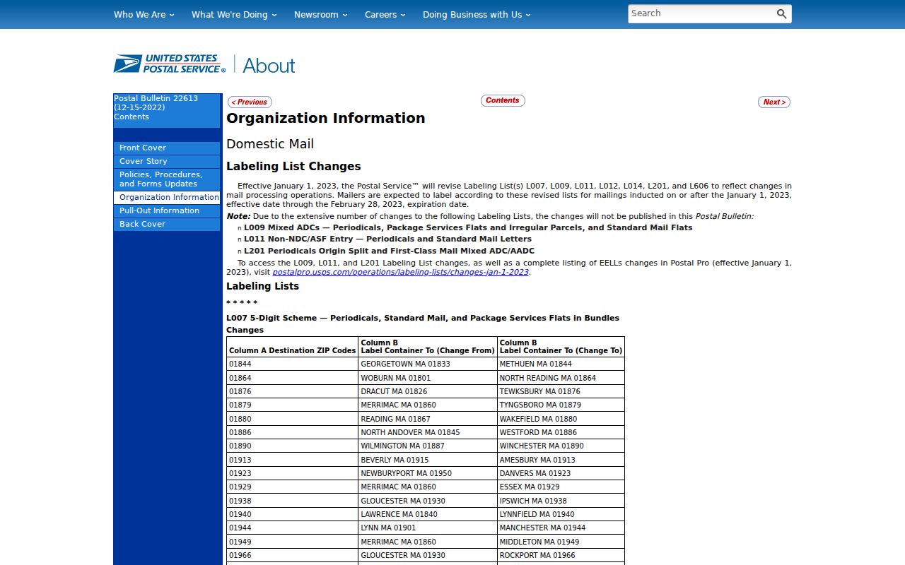
The later table helps connect old and current labels, yet it does not silently rewrite an old record. Historical directories should retain the ZIP and city spelling printed in their own year.
Crest Hill ZIP Versus City Limits
Crest Hill covers about 9.0 square miles in Census geography, but USPS zones extend according to delivery needs. A parcel can carry a Crest Hill last line near a municipal edge, or a city parcel can use a neighboring postal label. Township assessment context and fire service add more layers. The city is served by both Lockport Township and Plainfield Township fire protection districts depending on location.
- ZIP code
- A five-digit USPS delivery area, not a municipal boundary.
- ZIP+4
- The basic code plus four digits that narrow delivery to a smaller segment.
- PO-box ZIP
- A code used for post-office-box delivery rather than a general street area.
- Unique ZIP
- A code assigned to one large organization or institution.
- Carrier route
- A group of delivery points assigned to a postal carrier.
Compare six fields when geography is disputed: USPS last line, parcel municipality, township, ward, fire district, and Census place. A match in one field does not establish a match in all six.
Stateville's Crest Hill ZIP Split
Stateville Correctional Center gives a precise local example. Official material uses a physical Crest Hill address in 60403, while its mailing address is P.O. Box 112, Joliet 60434. The physical municipality and mailing destination are both valid within their own systems. Neither should be overwritten to make the labels look consistent.
This quirk also shows why a ZIP code directory cannot act as a list of residents. Institutional populations, post-office boxes, parcels, and delivery labels answer different questions. Record the field exactly as the source labels it: physical address, mailing address, postal city, municipality, or ZIP. An unlabeled address invites an error.
Local tip. Preserve both Stateville address forms and their source dates; use the physical parcel for maps and the current mailing line for correspondence.
Crest Hill ZIP Service Geography
The city's fire service page identifies Lockport and Plainfield township fire-district service areas. This is useful evidence that one city name can span separate service contexts. It does not define the postal boundary.
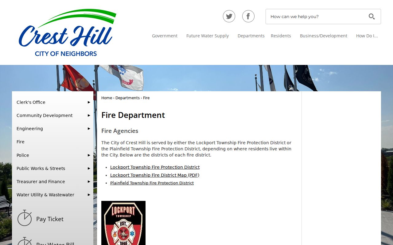
The same separation applies to tax maps and assessment offices. Store the township and service district beside the ZIP when the question concerns the responsible office, then confirm current coverage with that custodian.
Record a Crest Hill ZIP Mismatch
Do not force conflicting labels into one “correct” city field. A sound note records the full address searched, the USPS result date, recommended last line, five-digit code, assessor municipality, parcel PIN, township, and map source. If Recorder or historical material uses another spelling or ZIP, retain that text and its record date as a separate row.
Will County assessor Address Search accepts street number, street name, and city or town. The inspected form has no postal-zone field, and the county notes that 9-1-1 maintains addressing. Try the numbered street and city fields as stored before deciding a parcel is missing. Then ask 9-1-1 addressing or the township assessor about a discrepancy.
A matching PIN bridges the search into GIS and Recorder records. A full parcel number has 16 digits, while a common 14-digit form omits the first two computer-code digits. County GIS describes more than 70 layers, including parcels, land use, hydrology, public safety, aerial images, and transportation. These layers show context. They do not replace a survey, plat, deed, or boundary ordinance. Save the map date and layer names so another person can repeat the check.
Recorder DirectSearch is a separate system. Its advanced address fields are House No., Street, City, and Zipcode, and its parcel tab expects the Recorder's PIN format. Official tips say to run name, address, and PIN searches separately. A match points to a recorded instrument. Inspect the image or obtain a custodian copy before treating the index as proof of a legal fact.
Historical work adds another layer. The 2006 postal change can explain why an old directory, deed index, or newspaper uses 60431, 60435, “Cresthill,” Joliet, or another last line for a place now linked with 60403. Preserve the old label and year. Add the modern form in a new field instead of altering the transcription. That keeps a family-history trail searchable without making the source say something it never printed.
For an address-assignment or renaming question, contact Crest Hill's Clerk or Planning staff, Will County 9-1-1 addressing, the township assessor, Recorder Archives, or a local library desk. Existing municipal correspondence can be requested through city FOIA. Phone, counter, archive, and records-request channels matter when a form rejects an old street spelling or a change predates live tools. No verified citywide street-renumbering schedule or live citywide USPS response was found.
Note: A ZIP code result confirms delivery formatting, not a person's identity, current residence, property title, ward, township, or city-limit status.